

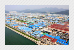
About Gangseo
- About Gangseo
- History
- Origin of the Place
Origin of the Place
Daejeo 1 & 2 dong
The name of the area seemed to be originated from Daejeodo island in the form of sand bar in the mouth of west Nakdong river which was part of the area of Daesang myeon, and Daeha myeon, Yangsangun, Gyeongsangnamdo. Daesang myeon is located in the upper side of Daejeodo island and governed Chuldu rhee, Sadeok rhee, Daeji rhee and Pyeonggang rhee. And Daeha myeon ruled Sodeuk rhee, Deukdurhee, Dodo rhee, Macdo rhee and Woolman rhee.
| place name | village name | the origin of name |
|---|---|---|
| daejeo 1 dong | sindeuk | Gimhaegun Daejeomyeontae is part of Sadeuk rhee. After the national road was built, it was divided from Sadeuksang rhee. As it was newly formed, it was called sinsadeuk, but, it was renamed as sindeuk |
| sangri | Before Nakdong river bank was built, it was formed near the river side hill, but, after the bank was built, it was relocated to the current site. The village was named sadeuk as there was lots of sand, it was named as sangri because it was located in upper side of sadeuk. the name was junggeum before. | |
| jangro | As Nakdongjang bridge to bring big change to Gangseo area in 1933 was built, the long road connecting the bridge was built. It is the current sinjangro. As there was a ferry with which people could cross to Gupo, 200m away from Nakdongjang bridge to the north, it was also called Naritga. | |
| byeondeuk | There were some houses and rice mill as the land was formed while the sand was accumulated up to the central part where nakdong river flowed before the current Nakdong river bank was built. One day the big flood occurred and flowed away much sand, but, in the place with lots of grass, there was no much damage, therefore, the residents got lots of luck, deuk in Korean, thus, it was named sudeuk. There lived lots of people whose surname was park, so, it is also called park village. | |
| dangri | As it was located on the top of Daejeodo, it was called Dangmalri. And since Dangsan was built first, it is said to be called Dangri. | |
| sinchon | It is located in the west side of Dangri village irrigation site. As it was formed last, then it was called sinchon.(sin means new) | |
| dongyeonjung | Long time ago, river overflowed when flood occurred and the strong flow of water flushed away sand and then the big pond was formed. It was called Yeonjung as Jungda was built near the pond. To the east, there is east Yeonjung and to the west, there is west Yeonjung. | |
| seoyeonjung | There is seoyeonjung village in the west of farm land improving daejeo pumping station irrigation ditch. During the Japanese colonial period, there were some houses along the bank road of irrigation ditch and people lived by field farming, but, as more people gathered, it became rather big village. | |
| daejisangri | It was named Daejiri as the village was formed on the big land of nakdong river plain. Daejisangri located on the upper side of Daejiri was the biggest village which was firstly formed in the area. | |
| jungchon | The village stretches out along the road connecting Daerisangri with Hari. It is located in the middle of 7 villages of Daeji, thus, it is called Jungchon(jung means middle in Korean) | |
| jungri 1 gu | Jungri village was formed on the site of west nakdong river floor before the big flood occurred in 1885. But, cause of frequent floods, it became a river and now the current village is formed in the place where most of sand was flushed away. | |
| jungri 2 gu | As the village became the mouth of west nakdong river curving into Pyeonggang stream, there were lots of reed fields, so it was called reed village. Once it was very barren land but as locals made endless efforts in changing it, therefore, now it is the place to grow vegetables. | |
| daejihari | As the sand accumulated when a big flood due to the summer time rainy season in 1865, the hillside was formed which made a village. It was called 'moraekakdan' and the village of Daejihari was formed in this site currently. As it is located under the land, 'araekakdan' became another name for this area(arae means lower side in Korean) | |
| pyeonggangsangri | It is located in southeastern side from the place where national highway No.14 and farm irrigation site meet each other. As there were lots of mulberry in the past, it was called Sangmokri. It is Pyeonggangsangri located on the top side out of Pyeonggangri, and there were several shops as it is located in the area where the road to air force base, Jungri 2 gu and the way to Busan prison are connected. | |
| pyeonggangdaeri | As you go to the rear door of airport along the Pyeonggangbyeon in national highway No. 14, the road is divided into the old road and big road at whose junction there is daeri village. Long time ago, there were a series of Chinese hackberry along the bank road of the village, so, it was also called pogunamukakdanilgo(pogu means Chinese hackberry in Korean) | |
| pyeonggangsari | 20 years already passed since cultivating the barren land only with reed forest as the sand bank was formed because the sand was accumulated due to the frequent flood in Pyengcheon stream. Pyeonggangsari village to be formed along the field road of irrigation ditch of Pyeonggang pumping station was the biggest village in Pyeonggangri where roof tile houses were crowded surrounded by the fences made of bamboo and bitter orange. | |
| pyeongganghari | It is located along the southern Pyeonggang stream of Sari. It is also located in the lowest area of Pyeonggangri. The villages suffer from the big noise made by airplanes taking off and landing. | |
| chiljeom | the village is located in the east side of Pyeongganghari. It is called chiljeomsan (chil means seven in Korean) as it looked to have only 7 tops of mountain peaks because the sea water went upward up to the middle part of the mountain in the sea. People started to live here around the time when Daejeo island became the shore. | |
| sinjung | The village is located in chojungrhee daedongmyeon Gimhaegun in the opposite side of west Nakdong river from Daejeodong. But, jurisdictionally, it is included in the land of Daejeo in Daedong myeon whose address is 30 tong 121-204 byeongji Daejeo 1 dong. |
Gangdong dong
It was once Deukdo myeon, Gimhae gun, Gyeongsangnamdo and governed four rhee's including Daesa rhee, Sangdeuk rhee, Bukjung rhee and Jedo rhee. As included in Garak myeon, Gimhaegun in 1914 and newly became part of Bukgu, Busan in 1978, it was named as Gangdong(east side of a river) dong because it was located in the east side of West Nakdong river from the side of the previous Garak myeon.
Myeongji 1 & 2 dong
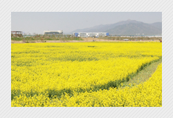
It is located in southern tip of Nakdong river mouth delta area and is the biggest leek and Haetae seaweed producer. Once it was good for salt production, so, Myeongji salt was very famous and as the whole island is covered with reed field, natural plant craft work using reed was the specialty. 85% of residents are from the area and they have strong regional unity as most of them graduate from the same primary school. The origin of name 'Myeongjido island' which means 'the sound resonating from the land' was from the story that the sound from a drum or a bell was spreading before natural disasters occurred.
Garakdong dong
The origin of the place name isn't well mentioned at documents or books, but, according to Gimhaejiriji, the ancient document, Garak means it extends over Nakdong water, therefore, it means the place near the big waterside. Nobody lived in Garak up to over 500 years ago, but, it became part of Gimhae after people moved to Garak based on Jukdo island, and as it became the jurisdictional area, Gimhaegun Garakmyeon, during the nationwide official reform in 1895, the late Joseon period, the 32nd year of king, Gojong's ruling, then finally the place started to be called Garak.
Noksandong dong
There are two theories about the origin of this place. One is that it was first Noksan, but changed into another Noksan which has different meaning with Noksan firstly mentioned in Chinese. That is, according to feng shui, the east side of Bonghwa mountain looked like a hungry deer running across the field, so, it was called Noksan but it is more proper to say Noksan is from the small island, Nokdo island.
The place name of Noksan is marked on Gimhae part map of Yeojidoseo, the ancient document, and the name of Nokdo is mentioned as Myeongrokyangdo in salt field related articles during the 11th year of king Sunjo's ruling according to another ancient time document, Joseonwangjosillok. In other words, Nokdo was just a small island up to the step of Yeojidoseo, but as the delta area of Nakdonggang river mouth was being formed, it became part of land. Therefore, even though it was recorded as an island since early 19th century, the salt field was very popular in this area with Myeongjido island, thus, it must have been already connected with land.
Gadeukdo dong
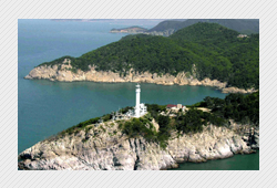
During 37th year of King Jungjong's ruling in Joseon, Cheonseongmanhojin and Gadeukjin were built in Gadeukdo to prevent Japanese invasion, Woongsunggun Cheonseong myeon and Gadeuk myeon were built in 1906 and since then, it was called Cheonga myeon by taking initials of two myeon's as two myeon's were combined in 1908.
Tel : 82-51-970-4000 Fax : 82-51-970-4444
Copyright(C) 2015 Busangangseo. All Rights Reserved.